B-1402, Kampung Pengkalan Arang, K. Nerus, Kuala Terengganu, Malaysia
The earliest recorded life events, in my possession, that took place around this venue was 1914, the year my father was born. Then, another event, with a more detailed record, took place at about 4 of the Friday morning, April 20, 1951, the moment I was born.
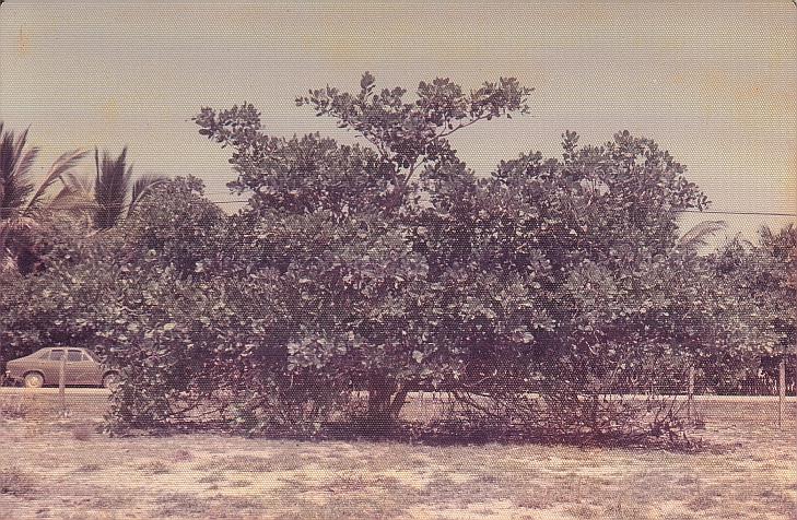
 The place was called Kampung Pengkalan Arang, literally translated as the 'Charcoal Jetty Village', and it was so called because there used to be several charcoal making hearths with a makeshift wooden jetty nearby, belonging to one of my great grandfather, or his close relatives and associates. It was on the eastern bank of Nerus river, a couple of hundreds meters wide, which flow roughly from north-west to south-east, a tributary of even much wider Terengganu river which flows from west to east. The charcoal was transported to the town from the jetty. Charcoal made at other places were also transported via the jetty. To date, the ground that used to be the sites of the hearth are still black, several feet down, charcoal particles are still visible, even to the naked eyes. The land however had changed hand many times, but the last time I remember it was still belonged to a relative of mine. Nonetheless, from that area, my father inherited two coconut trees, one I knew had fallen into the river when I was a very young boy. The second tree stopped bearing the fruits not long before my father passed away, it has then became intolerably high and only several feet away from the bank cliff. In the mid 90's that piece of land was repossessed by the state to be annexed to the then already crowded graveyard next to it, the graveyard in which my father, then my mother seventeen years apart, had been buried, side by side. I asked the consent of all my brothers and sisters for the compensation money amounting to less than a hundred ringgit to be given to my father's youngest brother, Ayah Li, to be donated to whatever religious charity he choose, in the name of my father and my mother.

 The kampung was about three kilometers from the mouth of Nerus river, joining the Terengganu river, the estuary of which in turn was only about four kilometers away, its outlet to the South China Sea. Both rivers were the main vein of transportation for the people in both interiors, and also the main life-lines too. Kuala Terengganu, the capital of Terengganu is on the southern bank of the Terengganu river estuary, in some parts about two kilometers wide. The northern bank, diffused along by the northern shore line of the South China Sea was called Seberang Takir, inhabited mostly by fishermen. This shore line, actually was only a small part of the entire coastal area, both to the north in Kelantan, extended to Southern Thailand, and to the south in Pahang and Johor of Peninsular Malaysia, where sea fishing was the way of life, the spirit of which resided very deep in my soul and blood, even as deep as in part of my DNA. I inherited a fisherman blood from my mother lineage and a trader-craftsman blood from my father lineage.
 UPDATED 2012: Viewing easwards along Nerus river, the loci is perhaps a hundred times more populated and developed than it was in 1960's. |
There was an inhabited island, called Sekati in the Nerus river mouth, probably used to be a delta, long, long time ago. Villages along the southern bank of Terengganu river facing the Nerus estuary were called Losong. A place in that Losong at the rivers junction was connected to a village called Bukit Datu on the eastern bank of Nerus river mouth, about two kilometers apart, by a ferry service, passing in front of Sekati island, operated by Public Works Department. The village, then specifically renamed Losong Feri, was connected on land by a trunk road to Kuala Terengganu, about six kilometers away. On the northern side, from Bukit Datu, the trunk road extended along the eastern side of Nerus river, up to Kota Bharu, Kelantan. In fact in the early days the road was part of the only trunk road spanning the eastern Peninsular Malaysia from Kuantan, Pahang to Kota Bharu, Kelantan. Perhaps the ferry service started a long ago, before I was born, during the British colonial time. The service was stopped in late 60's when new roads and long bridges were built to cross the rivers at many parts to connect places on both sides. These days no one can be called the trunk road, all of them are equally trunk road.
 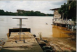 In 1960's life here was very hectic.This picture was taken in 2001 Dec, of what once the ferry dock at Bukit Datu. The Losong dock is on the other side, faintly visible. The mouth of Nerus river is on the right of the picture, hidden by the wooden stilted-house. This place once was part of the only east coast trunk road. |
 Kuala Terengganu from Kg Batin on the northern bank. Bukit Besar is at the extreme right. Seberang Takir is at the left, obscured by the docking fishing boats at the jetty. Pasar Payang is seen on top of the cruising boat, with Wisma Darul Iman the background. Duyung just missed, it is immediately on the right of the picture. The Trg River mouth is at the centre of the picture. In the 60's it was very wide, and thus the estuary was very open to the sea, and very deep. It was very windy and wavy. The boat ferrying passenger to-and-fro Seberang Takir were thus very big (like a junk) and used sails. Life were very busy in the estuary. |
 The passenger motorised-boat which was a vital transportation element in the 'civilisation' evolution in Kuala Terengganu, is still important today; unlike trishaw which has almost faded away. These boats shuttled the people in vein of Terengganu river and Nerus River. Today they still shuttle passengers, nonetheless in one and only left route: Seberang Takir - Pasar Payang route, a ten minutes journey. In my childhood, it was a joy to swim around the docking boats to load and unload passengers and their goodies at the jetty. |
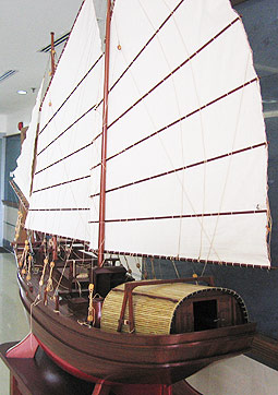 The "Perahu Besar" which were coomon giant objects along the river from Losong downstream, now a miniature fossilised into a wooden craft. A skill the Terengganu had lost forever. |
The district Pengkalan Arang was in was called Kuala Nerus, or more frequently called Nerus, since it covered an area around the mouth of Nerus river, but ironically only area on the eastern bank, even extended along the northern bank of Terengganu river estuary to include Seberang Takir. On the western bank, the district was called Manir, with a village in it also by the same name. The upstream area of Nerus river was called Hulu Nerus, but the area was very remote, not many inhibitants, much of the activities were of nature's routine, so Hulu Nerus was not frequently mentioned. I had been to the area only a few times in my life, although I passed through it many times. The trunk road to Kota Bharu passes this district. Incidently, the center of Nerus is in the vicinity of Pengkalan Arang. The activity center was about half a kilometer off the river, called Batu Enam, and was about ten kilometers from Kuala Terengganu by land, passing the ferry line. There was a well known market there, almost all commodities, necessities, and services were available, including, used to be a makeshift cinema. Batu Enam changes very fast and very often since it is on the trunk road to Kota Bharu. Its market had changed four times in four different location in my time I could remember within the vicinity.
 The last one-foot of once Bukit Tunggal (2001 Dec), a hill, a landmark of the area. It took about forty years to flatten this hill. |
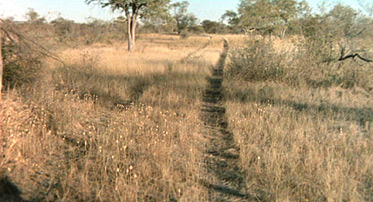
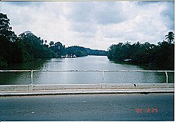 Nerus river viewed on the bridge eastward. The jetty on the left bank is "pengkalan arang". |
 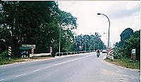 The Manir bridge(left) and its little sister Buluh Gading Bridge (right), built at about the same time in the 60's had brought revolutionery changes to the life about them. |
The Buluh Gading bridge brought a lot of changes to many people. It created and resumed relationships, cherished, united and reunited many people and families on both side of the river. Many people could do many more things when they could cross the river by the bridge on foot, or in a vehicles, even on a bicycle, and much more and many different things can be moved or carried across the river. I imagined the same thing happened to the people on both sides of the Manir bridge, and in fact Manir bridge and Buluh Gading bridge contributed to each other's changing function. I have many relatives I had known living on the western side of Nerus river, and I came to know more after the Buluh Gading bridge was opened. Immediately northward from Buluh Gading, was a village called Paya Datu, a village later became part of my very existence, not only because later I discovered that there were many relatives lived there, but I was destined to start my own family from there, with a girl my mother had considered the most fit for me. Through Paya Datu, passing Kampung Tengah I went to Banggol Donas, a village full of my relatives, particularly my father's elder sister, Mak Ngah whose uniqueness of almost a virtual reality I would probably never found a duplicate in her kindness and care for me, my family members, and in fact all the people she knew. I became more agile, not only among my relatives, but also among my newly won friends, since then had expanded beyond the boundary of my birth place, from different loci due to different reasons as I went on my phases of life. Unfortunately, I missed to fully witness and undergo the evolutionary changes that took place around my place because by January 1964 I went to stay in the school hostel, then in January 1967 I went to school as far as in KL. Since then I slowly transmuted myself to become a stranger in my own birth place. The transmutation completed in 1983 when I joined the staff rank of Universiti Kebangsaan Malaysia after going to England twice, once in 1974 for two years, the other in 1979 for three and half years, with a well growing family. In 1983, I settled down in Bangi where I earned my living as a lecturer in the Chemistry Department of UKM.
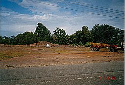
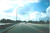
 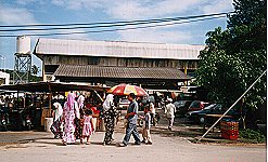 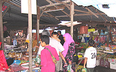 Batu 6, the round about and the market place in 2001 Dec. Forty years ago this market place was just open space below hugh and tall trees, and the road was just pebbled and foot-path. I grew up to a boy in this area, a boy later known to every inhibitant in this place. My mother eventually found a nich in this market, unfortunately towards the end of her life. |
I have not been to Duyung since the bridge was built, and I wonder how they managed their vehicles with the already packed area. Unfortunately the bridge was built with a cost born by the people. It was tolled, right in the middle of it, right between Duyung and Pengkalan Batu. When it was first opened in the mid 80's, the toll fees, fifty sen, was put only on the south-bound vehicles, thus giving the privilege to Duyung inhabitants a free pass to and from their place. In the mid 90's, in the middle of toll rise season everywhere in the country, both ways were equally tolled.
  A typical coastal fisherman village along the beach up to Merang and Penarik. It has been like this since I was a child, not much change to this date, except that the houses those days were made from material gathered, rather than material purchased. |
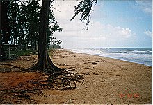 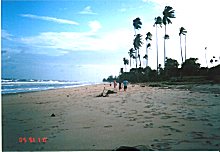 The South China Sea coast of Terengganu; from Kemaman, Dungun, in particular Kuala Terengganu, from Seberang Takir to Batu Rakit, Merang, through to Penarik in Setiu up to Semerak in Pasir Putih, Kelantan. |
   The serenity near Wakaf Baru in 1976 (left); the precursor to what is known today Taman Salwa and many more small housing "tamans". Middle - Wakaf Baru in 2001 Dec; Right - some 'pure breed' of the area that survived, the kind I had my frolics with in the 60's. |
  In early 60's Wakaf Padang looked like this, viewed towards the coastal area, Kubang Badak, while sitting on the shed under the 'sepetir' tree. Near the shed there was a deep well for the travelers to quench their thirst and more often to wash to pray. The ground was filled with long round grass called 'rumput bedil' (literally translated 'gun grass', because when it is on fire, it gives rattling sound like gun fire). The 'road' from this place to Kubang Badak, then Tanjung Gelam, and along the beach to Mengabang Telipot, Pengkalan Maras, Mengabang Telung, Batu Rakit, through to Mengabang Panjang, Ru Tapir, and Merang, are tracks like this. On the beach however, they were lined by coconut trees, not savannah like this. |
  Tuan Chilik, one of the oldest elders in Bt 6. He watched every single evolution that had turned Bt 6, from the gravel path to the very busy motor vehicle tarmac; (pic: 2006 Jun 6 Tue) |
Today, the Forest had changed, and had undergone the changes, with its extensiveness no one at all expected and ever imagined. From a place where no one was brave enough to go alone, the Forest had changed to a place every one wanted a site to reside. It started with a factory in mid 70's, a plywood-veneer factory. Wakaf Baru had been razed to the ground, it became the sites for Technical School, Science School, Mosque, and rows of shops lots and surrounded by many residential parks. Wakaf Padang became the site of Religoius College, another mosque, and rows of SMI factories, and of course residential parks. Kubang Badak became the site of a University College. The airport was enlarged to cater for at least Boeing 737. Janjung Jaafar became the site for Terengganu sport center. 'The Forest' now become a suburb, and the most expensive area in the outskirt of Kuala Terengganu, and Kuala Terengganu municipality has since been extended to include Batu Rakit. The whole area is now called Gong Badak. Wakaf Baru was renamed as Wakaf Tembusu, a name for a place previously much closer to Batu Enam. And commodities in Batu Enam market became the most expensive commodities in the whole Kuala Terengganu. In short the fast changing Batu Enam had raised the cost of living phenomenally, but not necessarily the standard of living though.
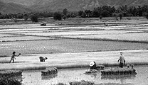
Changes along the trunk road from Batu Enam to Kota Bharu were rather slow because these were among the early settlement areas. It was padi field on both sides of the road up to a small village town called Tepoh. There was a police station in Tepoh, a second police station after the first in Seberang Takir in Nerus district. Nerus district has only two police stations. My birth was registered at this police station, so did virtually all other birth in my time. Giving birth in the hospital was unheard of, except for cases with severe complications. Before reaching Tepoh there was an area called Padang Air (trl. Water Field) because those days, one could see only padi fields, and in monsoon season it would looked like but fields of water. At Tepoh there is a road to the eastern interiors inhabited mostly by farmers and the road lead to Batu Rakit, passing another small village town called Maras. The trunk road runs into the western interiors, into the Hulu Nerus district, with farmers and animal rearers up to Gemuruh, fifteen kilometers away, then it was a vast virgin jungle which I had not have a chance or reason to go when I was a kid. But I was told that there is a hilly area, 'full' of the hills called Bukit Jong. Apparently there was a quarry in Bukit Jong. Stones and pebbles for the road making were taken from this quarry.
In Tepoh market, farmers congregate to trade their produces, and they came from the vicinity. Interestingly the market operated on Monday and Thursday only. Another interesting thing about Tepoh market was that it became the meeting place to exchange goods of sea produce and land produce since the traders were both from the interiors as far as Gemuruh with all kinds of fruits and land produce, and from the coastal area as far as Mengabang Telipot and Batu Rakit with their sea produce, and the places in between like Maras, Padang Nenas, Padang Kemunting, Bukit Titi, Bukit Wan, Darat Batu Rakit, Pecah Rotan, Linga, Sungai Ikan, Bukit Guntung, Leret, and Padang Hangus. There was a past mid-night bus service to transport traders from the coastal area to Tepoh, and obviously twice a week, so that they could start trading when the sun rise. Tepoh market was a very familiar place to my father. He knew many people in Tepoh and many people knew him. In his young days Tepoh was a very favourite place for him. He preferred being and buying goodies in Tepoh, four kilometers away than being and buying sundries in Batu Enam, four minutes cycling away. My elder brother and I had the same opportunity when we were small. In fact Tepoh had played a key role in my growing up, in harnessing the relationship between my father's family and my mother's family. My father had many relatives living in the western interiors, and they were farmers. Apart from my mother's relatives who came from Batu Rakit and Mengabang Telipot to trade their produce, my father had many friends, customers and colleagues coming to Tepoh twice a week.
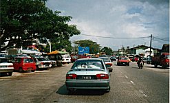
    A typical view in the bone-shaker in the 1960's from Tepoh to Maras. Dec 2001, the dead Tepoh shops and the market, and the rebuilt Police Station on the raised ground. |
My father was a known and favourite carpenter, building wooden houses. But he was a farmer too. He grew padi, sweet potatoes and other annual crops himself, more than sufficient for his family year around staple food. My mother helped him. Normally he turned farmer during monsoon season, like every body else, when the rain comes. During this season he fished as well in the fields, and sometimes in the river. He inherited from his father a padi field in a place called Titian Hj Ahmad, a place just after Pak Katak, the village opposite to Pengkalan Arang. Actually Titian Haji Ahmad was a wooden bridge about fifty meters long across a swamp from Pak Katak to Gong Kijang, and it was named after his father, Haji Ahmad, perhaps for a large portion of fund from him to build the bridge. I remember helping my father in that field and in other people's fields where in some years he rented them.
| 2007 Oct 4 Thu Update. In the late evening, a revisit to a beyond Pak Katak where my grandfather had built a foot-bridge for the farmers surrounding its vicinity to reach their "sawah". The bridge was named "Titian Haji Ahmad", and his sawah was along it. I had sometimes when I was a little boy helping my father to grow padi there. The place dislocated from my locus when I became a hostel boarder in 1964. As of today, the bridge was marked into the reserve for the road. So, in a few years time, Titian Haji Ahmad would become a tarmac road passable by motorised vehicle including cars. |
 |
It used to be padi in its season and nothing else on both side of the bridge because the sawah was deep. It actually joined Pak Katak and Gong Kijang, a place as wild as the "forest". Pak Hasan who stayed at end of the titian was a good friend of my father. He lived by making coconut sugar.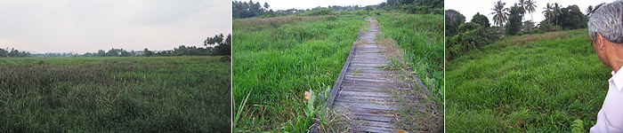 |
The southern and western part of Kuala Terengganu were foreign lands to me when I was below ten. My father and my mother had many known relatives as far as Pahang to the south, and Kuala Berang to the west, but in my kiddy years we had never been to the area. Kuala Berang is to the west, about forty kilometers away. But I had been only up to Bukit Payung, fourteen kilometers from Kuala Terengganu. I remember my father took me once to Pak Madah, two kilometers off Bukit Payung, to visit his one and only maternal auntie, and it was a feast time, wedding or something. Bukit Payung only became very familiar to me in 1965 and 1966 when I was in Secondary School in Padang Midin, about four kilometers before Bukit Payung on the main road. Within that two years the area became my new loci, then already well connected with tarmac roads, including in the area off the trunk road such as Paloh, Durian Burung, Kuala Bekah, Pulau Musang, Sungai Rengas, and Pengadang Baru, through into the interior between the two rivers including Manir itself, Teluk Pasu, Tebakan, Pulau Bahagia (previous name, Pulau Babi), Batu Hampar, Telemong, Kesom, Beladau Kolam, Beladau Selat, and Jeram. By then I had added more friends, from the school. My first arrival at Kuala Berang was in 1973, with a fellow-state friend I met at the University, Jamaludin, who asked me to accompany him, apparently to visit his girlfriend. In my adult years, I went to or passed by this western areas more than the northern areas. In fact I practically abandoned the northern areas, even if I went to Kelantan, or comming from Kelantan I would use the coastal route, connecting Batu Rakit, Merang, Penarik, Setiu, Semerak to Pasir Putih.
    The lagoon of Ibai river, and the beach of Chendering in late 1960's. The former less frequently and the latter more frequently and popularly visited by "outsiders" for leisure time on the weekends. |
There was another English school in KT, but less well spoken about, the Tengku Bariah Secondary School, or TB for short. Until 1964 there were no secondary school for Malay medium instruction, even though such school system had already been established since 1960. Schools in other parts of Terengganu were also English school. There was Dungun English School (DES), and Sultan Ismail School in Kemaman (SIS). The first Malay medium secondary school in Terengganu was opened in October, 1964 in a then remote area called Padang Midin, about ten kilometers westward to Kuala Berang. Before the opening, all students were put temporarily in the established English schools. By 1965, all Malay medium secondary school students congregated in Padang Midin, from Besut in North Terengganu to Kemaman in the south. I went to Malay medium school because my mother could not afford the monthly fees, about six ringgit. In the new Malay medium school the fees were only six ringgit a year. I went to the Malay medium school for this very reason, and not any other reason, and especially not because my Standard Six Examination results could not make it. I got an A grade in that exam, with another boy, Ismail Embong, out of all the standard six pupil in my school, and with that A ticket I won a Federal Minor Scholarship that took me through to the secondary school, alas a Malay medium School. I in fact had a chance to go to English primary school in 1962 when I passed the Special Malay Exam in Standard Four in 1961. It would have been to the Sultan Sulaiman Primary School in Batas Baru, the Primary equivalent of SSSS. But it was entirely unimagined of, since how much tears it would take my mother to make the sufficient money was one thing, to commute to the school from my home was another. My classmate Ambak who lived in Bukit Tunggal went to the English primary school after Std Four, but he did not make through after Standard Six. My other A-mate Standard Six classmate went to TB, but he too did not make it through to the end.
My wife went to TB for her secondary school, of course I knew this after I married her. Her father was a clerk, thus much richer than my father, he could afford to send his daughter, his first child to the English School. Her place, not her home, became my locus only after the Buluh Gading bridge was opened. I was on the bicycle to my aunt's house in Banggol Donas, further up. Later, when I was about eleven or twelve I cycled through her village selling bread, which I bought in Pulau Kambing, shared with my elder brother, during Ramadan. I did notice the house which later destined to become my in-law's house, but its inhabitants did not attract me at all, my future wife was then only seven or eight years old and I did not remember seeing her around, and while I was myself very poorly dressed, she perhaps still needed help to get well-dressed. None of them had ever bought the bread I sold anyway. Ironically, the house before her house (Tok Ngah Tok Kik) and another house after her house (Pak Teh Mat) along the road, less than fifty meters apart between each other, were my father's close relatives house which I often visited. There was a primary school in Kampung Tengah, the school my wife went to during her primary, and the school her father too went to. My father and my mother did not go to school, both were illiterate all their life, but both were very fluent Quran readers and they were Quran teachers. My father was very much older than my wife's father.
As I grew bigger and older my loci became larger and larger, and largest among my brothers and sisters. The destiny took me from a place to another, and then another. We do things in one place to prepare ourselves for the next clueless place. I was taken by the destiny to different places that I previously had no idea at all, and do things which I had not dreamt of before to do it. Things that I wanted to happen and done sometimes did not happen and undone because they are not included in my destiny. That because our mind are actually independent of our fate. We wish with our mind, but they are fulfilled by our destiny. Nonetheless, sometimes they happened and get done in different ways, in different places and in different times. A life itself, such as my life repeated itself over and over again in many different ways, different places and different times. I believed some where in some times there was, or are, or even are going to be another life like my life in many ways.
I was born in 1951 in Kampung Pengkalan Arang, Kuala Nerus. Nowadays I am a stranger in my own birth place, a stranger to the contemporary inhabitants, but I was and I am a very dear friend to the places that used to be my loci. I was thirteen in 1964 when I first parted with my birth place, apparently southward in my own trial of life. Since then I returned home only four or five times a year. I began my transmutation to become a stranger in 1967 when I left Terengganu for Kuala Lumpur, and further away to England in 1974. The transmutation completed in 1983 when I returned to Malaysia and signed to become a teaching staff at a local University in Bangi, Selangor, a township built in the late 70's. I settled down in my own home with my own family in the new land in 1987, in Sungai Merab, the birth loci of my children, near my feeding ground. The changes brought about by the development in my birth place had brought along new people, strangers not only to myself but also to my fellow folks, who I then rarely met when I returned home because like myself they are also on the move in their own trial of life. My father passed away in 1972 and my mother in 1989 in the place where they brought me up, but they left me with thousands of relatives, close and distant, and some of them among the strangers, who built my feeling never more at home than with them. I married a girl from a village not very far from my birth place, a distant relative, in 1976 when I was twenty five. She had not only given me herself, but also her parents, her brothers and sisters, and her relatives, thus swollen my birth place with relatives. She gave birth to my first child in 1978, a daughter, when we were in Kuala Lumpur. The house in which I was born, even though had since became my youngest sisters', had undergone changes many times, by the fund mostly of my contribution, but it is still at the same site, the site of my father's father home. It was then unchanged since my mother passed away, and it was the house with the feeling that my mother and my father are still in waiting to welcome me home every time I return to visit them that bonded me strongly to my birth place to this day. If I can choose, I want to choose to go back to my birth place and to my relatives, my soul, my flesh and my blood for one would know his or her path ahead.![]()
Edition dated: Mac 2003.